Colorado Maps - Durango Area Map - The Colorado Vacation Directory

The Colorado Vacation Directory

TOWNS & AREAS    |    PLACES TO STAY    |    FUN THINGS TO DO    |    COLORADO MAPS

towns, areas
northwest colorado map
southwest colorado map
north central colorado map
south central colorado map
eastern colorado map
local areas
national parks & monuments
scenic byways
free colorado map to download and print
cabins, cottages
lodges, motels
lodges, motels
vacation homes
suites, condos
bed and breakfasts
tent camping sites
rv parks
rv services
romance packages
family activities
dogs ok
properties by water
swimming pools
guest horses
groups, reunions, weddings
winter activities

Durango Local Area Map

click here for Vallecito Lake Chamber

Click Symbols on Map for More Information Durango, Colorado Map, The CVD Ignacio, Colorado, The CVD Bayfield, Colorado, The CVD Durango, Colorado, The CVD Durango & Silverton Narrow Gauge RR, The CVD Animas River Rafting Durango Jeeping & ATV Trails Map The Colorado Trail Map San Juan Skyway Scenic Byway Map Durango Snowmobile Trails Map Pagosa Springs West Snowmobile Trails Durango Mountain Ski Resort Legend of Map Symbols 
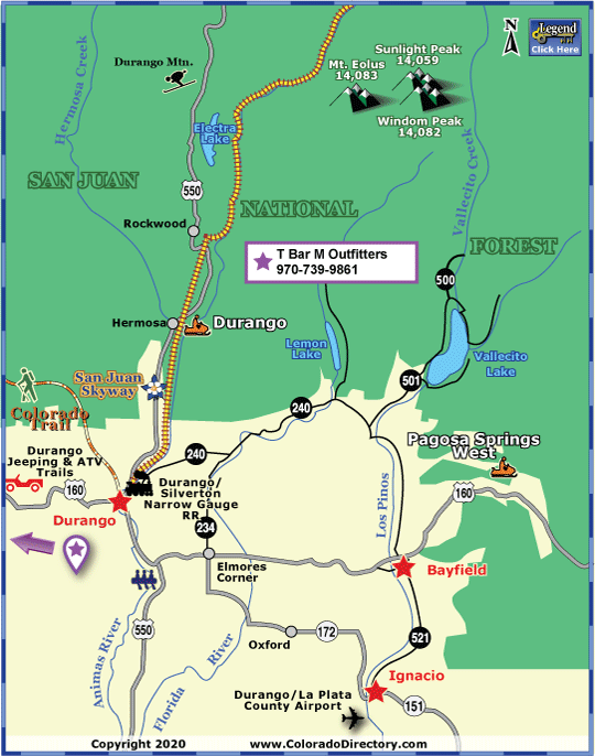
Not all towns appear on map. The publisher does not assume any responsibility for accuracy or completeness of maps. This information was compiled as accurately as possible.


Durango was established in 1881 when Denver and the Rio Grande Railroad built a track to Silverton. Durango was named as the hub of the railroad system to transport ore from the mountains to smelters in Durango. Today, the city retains a "Frontier West" feeling. Surrounded by the San Juan Mountains and set amidst reddish, sandstone bluffs, this town bustles with activity. Many of the original buildings constructed by Durango's pioneers are still in use today. They can be seen in the historic districts of Third Avenue and Main Avenue.

The famous Durango-Silverton Narrow Gauge Railroad is the country's only coal-and-steam-powered train operating daily. Chug along sheer cliffs, criss-crossing the Animas River on the 45-mile trip to Silverton. The train has been running for over 120 years, yet the Durango railroad depot looks the same as when it was constructed in 1882. The line was constructed to haul silver & gold ore from the San Juan Mountains, but passengers soon realized it was the view that was truly precious. Today, the railroad carries about 200,000 passengers per year.

Durango provides many water areas for recreation. The Animas River, or river of lost souls, has wild whitewater rafting during spring run-off and settles down in the summer for family jaunts. The river is one of the last free-flowing rivers in the Western United States. Rent a bike for a day and discover why this area is so popular with mountain bikers. Vallecito Lake, located 23 miles northwest of Durango, lies under the snow-capped peaks of the San Juan National Forest. This lake is an angler's delight -- fish for rainbow trout, kokanee salmon and northern pike. Several boat ramps and docks surround the 22-mile lake shoreline.

The Vallecito Trail and the Pine River Trail give access to the Weminuche Wilderness where mountain bikes are strictly forbidden, but hikers and horseback riders are welcomed. Other activities in the area include kayaking, hunting, backcountry and mining tours, golfing, rock climbing, live concerts, gaming, art gallery walks and much more. 25 miles north of Durango is Durango Mountain Resort (FKA Purgatory Ski Resort), which offers the unpretentious skiing of the southwest.

Cyclists should also check out the Iron Horse Bike Classic, which began in 1972. The road bikers race the D&SNGRR to Silverton on Memorial Day weekend. It is the longest, continuously run, cycling event in the United States.


For More Activities & Information:


Durango - includes Bayfield, Hesperus, Ignacio, Lemon & Vallecito Lakes
Durango Jeeping & ATV Trails Map
The Colorado Trail Hiking Map
San Juan Skyway Scenic Byway Map
Durango Snowmobile Trails Map
Pagosa Springs West Snowmobile Trails

Aspen & Crystal River Valley Local Area Map / Buena Vista, Leadville & Park County Local Area Map / Colorado Springs Local Area Map / Denver Metro Local Area Map / Denver Mountain Local Area Map / Durango Local Area Map / Estes Park Local Area Map / Grand Lake Local Area Map / Greater Gunnison Local Area Map / Lake City Local Area Map

Montrose & Ouray Local Area Map / Pagosa Springs Local Area Map / Pikes Peak - Colo. Springs Local Area Map / Rocky Mountain National Park Local Area Map / Royal Gorge & Canon City Local Area Map / San Luis Valley Local Area Map / Steamboat Springs Local Area Map / Summit County Local Area Map / Vallecito Lake Local Area Map

colorado maps
calendars of events
national parks & monuments
scenic byways
fishing, fly fishing
hot springs, mineral springs, mineral bath
horse rides, horseback riding
atving
jeeping
rafting, kayaking, whitewater
attractions
golfing
meals served, fine dining, food, restaurant
museums, ghost towns, caves, mines, tours, sight-seeing
hunting, guides, outfitters
snowmobiling
downhill skiing
snowshoeing
cross-country skiing

The Colorado Vacation Directory

Order your FREE Colorado Directory here! | Download our Colorado Map here

Colorado Towns & Areas | Places To Stay | Fun Things To Do | Colorado Maps
Links | Help | Contact Us | About Us

| Cabins & Cottages | Motels & Hotels | Mountain Lodges | Vacation Homes | Condos, Suites & Townhomes | Country Bed & Breakfast Inns | Tent Camping Sites in Campgrounds | RV Parks & Campgrounds | RV Sales, Services, Rentals & Manufacturers | Romance Packages | Family Activities | Dogs OK/Pets Welcome | By Water Accommodations | Swimming Pools | Guest Horses | Groups, Reunions, Meetings, Retreats & Conferences | Weddings & Elopements | Open in Winter | Calendars of Events | National Parks, Monuments & Historic Sites | Scenic Byways | Fishing | Hot Springs | Horse Rides | ATVing | Jeeping & 4WD | Rafting & Kayaking | Golfing & Golf Courses | Restaurants | More Fun Stuff | Hunting | Snowmobiling | Downhill Skiing | Snowshoeing | Cross-Country Skiing

Copyright by The Colorado Directory, Inc. This is a directory only; it is not and does not contain a recommendation,warranty, guaranty, inducement or endorsement of any kind. Representations herein were supplied by the individual businesses. The publisher, The Colorado Directory, Inc., does not assume any responsibility for truth, falsity or completeness of any representation made herein or any errors, changes, services rendered, or changes made in the use of this directory. This information was compiled as accurately as possible. Prices and services are frequently subject to change. Errors called to the publisher's attention will be corrected in the future. All rights reserved. No part of this publication may be reproduced, stored or transmitted in any form or by any means, without permission in writing from the publisher.