Colorado Hiking & Backpacking Trails
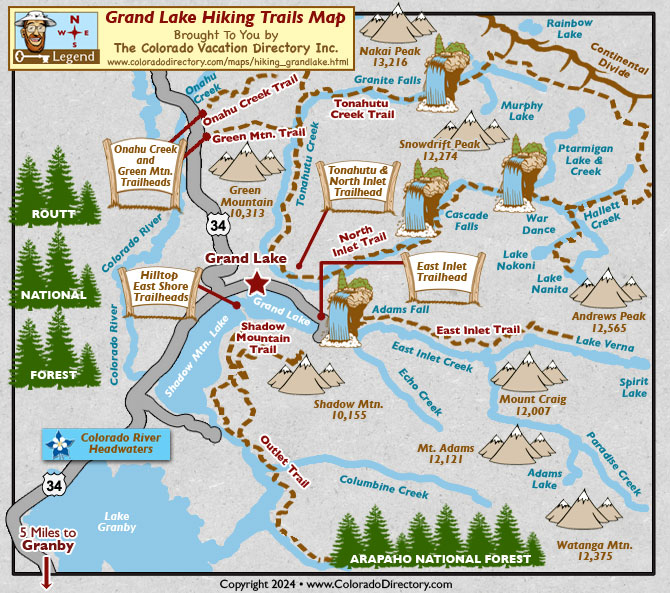
Grand Lake Hiking Trails
Not all towns appear on map. The publisher does not assume any responsibility for accuracy or completeness of maps. This information was compiled as accurately as possible.
Grand Lake Hiking Trails
(Note: Trailhead descriptions run from south to north, mileage given is one-way.)
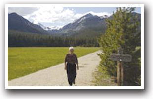
Running from easy to moderate to hard, Grand Lake's scenic trails offer something for everyone. Check out trail descriptions below to find the hike that's right for you, whether it's a quiet stroll near a waterfall or a day-long backcountry trek.
Alpine Visitor Center Trailhead
From this trailhead, access the Forest Canyon Pass trail, an easy, downhill, 2 mile hike.
Elevation: 11,796 ft.
Directions: Located off Fall River Pass along Trail Ridge Road.
Bowen/Baker Gulch Trailhead
The Onahu Creek Loop is a moderate, quiet stroll of about 6.5 miles. The Long Meadows trail (3.7 miles, 1,475 ft. gain), a moderate hike that's great for viewing wildlife, also starts from this trailhead.
Elevation: 8,864 ft.
Directions: Trailhead is about 6.5 miles north of the park entrance on Highway 34.
Colorado River Trailhead
Hikes from this trailhead: Beautiful hikes of all difficulties can be found from this trailhead. Take the easy 3.5 mile trail up to Lulu City, site of an 1880s mining town. Or try the moderate Little Yellowstone (5.1 miles, 1,021 ft. gain) or Skeleton Gulch trails. Those seeking difficulty can try out the trail to Lake of the Clouds (6.9 miles, 2,240 ft. gain), a rocky trek that gets harder near the end. Or head up difficult La Poudre Pass (7.4 miles, 1,501 feet) to cross the Continental Divide or Thunder Pass (6.9 miles, 2,321 ft. gain), a route once used by stage coaches.
Elevation: 9,010 ft.
Directions: Head 9.5 miles north of the park entrance on Highway 34. Trailhead has a picnic area.
East Inlet Trailhead
The easiest route from this trailhead leads to Adams Falls. At .6 miles with a gain of 79 feet, it's a nice stroll to a beautiful waterfall. Hikers looking for a moderate challenge can try the Lone Pine Lake trail (11 miles, 1,494 ft. gain) or the trail to Lake Verna (13.8 miles, 1,809 ft. gain).
Elevation: 8,391 ft.
Directions: Drive east from Highway 34 on 278 toward Grand Lake. Bear left at all forks until you reach the parking lot.
Grand Lake East Shore Trailhead
From the Grand Lake East Shore, you can hike up to Shadow Mountain Lookout, a fire lookout on the register of National Historic Places. This moderate hike is about 4.8 miles long, with 1,533 ft. of elevation gain.
Elevation: 8,390 ft.
Directions: Driving into Grand Lake, bear right at the Sombrero Stables, and turn right at the first street. Keep going until you run out of paved road.
Green Mountain Trailhead
The Valley Trail, a 5.5 mile loop, is an easy stroll from this trailhead. Or try the moderate hike to Granite Falls (5.2 miles, 1,046 ft. gain). Hikes to Haynach Lakes (8.3 miles, 2,286 ft. gain) and Flattop Mountain (10.3 miles, 3,530 ft. gain) are available for those who want longer, difficult trails.
Elevation: 8,794 ft.
Directions: Trailhead is 3.5 miles north of the park entrance on Highway 34.
North Inlet Trailhead
All hikes from this trailhead will lead you to beautiful falls or lakes in Rocky Mountain National Park. Hike to Cascade Falls (3.5 miles, moderate difficulty) or North Inlet Falls (7.6 miles, moderate to difficult). Or try out the more difficult hikes to Lake Nokoni (9.9 miles, 2,240 ft. gain) or Lake Nanita (11 miles, 2,240 ft. gain).
Elevation: 8,540 ft.
Directions: From Highway 34, head east on 278 toward Grand Lake. Bear left at all forks until you reach the trailhead.
While Hiking in the Grand Lake Area
Onahu Creek Trailhead
Try out the moderate trails to Parika Lake (5 miles, 2,496 ft. gain), Blue Lake (11 miles, 1,880 ft. gain) or up Baker Pass (5.75 miles, 2,389 ft. gain). The trail to Bowen Lake, a 7 mile trek through thick forest, and the trail up Bowen Pass, a 7.5 mile, steep hike, are ideal for skilled hikers.
Elevation: 8,765 ft.
Directions: Trailhead is about 3.5 miles north of the park entrance on Highway 34.
Timber Lake Trailhead
The Timber Lake trail is a 4.8 mile, moderate hike through the flower-filled meadows below the lake. The Long Meadows trail (5.5 miles, 1,480 ft. gain) is a more secluded, moderate hike, great for moose and elk watching.
Elevation: 9,000 ft.
Directions: Trailhead is about 9.5 miles north of the park entrance on Highway 34.
Tonahutu Creek Trailhead
Hike along the Tonahutu Creek on the Big Meadows trail. The easy hike is 3.2 miles with a small elevation gain of 880 feet.
Elevation: 8,560 ft.
Directions: Drive east from Highway 34 on 278 toward Grand Lake. Take a left at all forks until you reach the parking lot.
Places to Stay & Fun Things to Do
Columbine is pet friendly! Cozy mountain cabins with kitchens and Queen beds. Year round FUN at the west-end of Grand Lake. Walk to Western Boardwalk or Lake. Family picnics. BBQ grills. Outdoor hot tub.
160 acres near Grand Lake, the Resort Village borders Rocky Mountain National Park along a winding river. A family reunion destination: Cabins, campsites, lodge room. Vacation with your horse! Free WiFi.
More Local Information
Grand Lake, Colorado includes: Granby, Ski Granby Ranch
Hiking Trails in Colorado