Colorado Jeep & 4WD
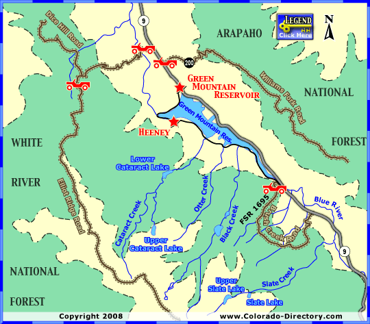
Green Mountain Reservoir Jeeping & ATV/UTV Trails
Not all towns appear on map. The publisher does not assume any responsibility for accuracy or completeness of maps. This information was compiled as accurately as possible.
Brush Creek Road - Be sure not to miss the turnoff, a little more than a ½ mile from Colorado State Highway (SH) 9, Forest Service (FS) Road 1695 takes a sharp left for scenic drive along Brush Creek. The road requires a bit of technical driving skill so be alert!
Williams Fork Road - Beginning at SH 9, Williams Fork Road (County Road 200) travels along the Williams Fork Mountains west ridge. Over 11 miles and more than 3,000 feet in elevation, look for spectacular views of Green Mountain Reservoir and the surrounding mountain ranges.
For complete Jeeping & ATV Information near Green Mountain Reservoir Contact:
Dillon Ranger District
680 River Parkway PO Box 620 Silverthorne
Silverthorne, Colorado 80498
970-468-5400
More Activities & Information
Summit County, Colorado includes: Breckenridge, Copper Mountain, Dillon, Frisco, Green Mountain Reservoir, Heeney, Keystone, Silverthorne
Jeep & 4WD in Colorado