Colorado Maps - Ridgway Snowmobile Trails Map - The Colorado Vacation Directory

TOWNS & AREAS    |    PLACES TO STAY    |    FUN THINGS TO DO    |    COLORADO MAPS

towns, areas
northwest colorado map
southwest colorado map
north central colorado map
south central colorado map
eastern colorado map
local areas
national parks & monuments
scenic byways
free colorado map to download and print
cabins, cottages
lodges, motels
lodges, motels
vacation homes
suites, condos
bed and breakfasts
tent camping sites
rv parks
rv services
romance packages
family activities
dogs ok
properties by water
swimming pools
guest horses
groups, reunions, weddings
weddings
winter activities
snowmobiling snowmobiling

Ridgway Snowmobile Trails

click here for info on banner advertising

Not all towns appear on map. The publisher does not assume any responsibility for accuracy or completeness of maps. This information was compiled as accurately as possible.

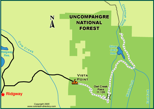
Snowmobilers near Ridgway can discover just why the San Juans are the most photographed mountains in the world.

The Owl Creek Pass trail takes riders up 10,114 feet into the peaks to enjoy the breathtaking views and scenery the mountains offer. Numerous ungroomed side trails can take adventurous riders into the Cimarron Forks area, where plenty of high country meadows are waiting to be played in.

To access the trail, turn east off Highway 550 onto County Road 10 (Owl Creek Pass Road) and travel 9 miles to the Vista Point overlook and parking area. Two trails leave the trailhead but eventually rejoin further up the pass.

Use caution and heed all warnings, though - this area is avalanche terrain.

Return to the Top

More Activities & Information

Ouray - includes Ridgway Montrose & Ouray Area

Return to the top

Return to the Top

colorado maps
calendars of events
national parks & monuments
scenic byways
fishing, fly fishing
hot springs, mineral springs, mineral bath
horse rides, horseback riding
atving
jeeping
rafting, kayaking, whitewater
attractions
golfing
meals served, fine dining, food, restaurant
museums, ghost towns, caves, mines, tours, sight-seeing
hunting, guides, outfitters
snowmobiling
downhill skiing
snowshoeing
cross-country skiing

Order/Download The Colorado Vacation Directory | Download our Colorado Map Here

| Join Our Newsletter Mailing List

Colorado Towns & Areas | Places To Stay | Fun Things To Do | Colorado Maps
Links | Help | Contact Us | About Us

A-Z List of Accommodations | A-Z List of Fun Things to Do | Cabins & Cottages | Motels & Hotels | Lodges | Vacation Homes | Condos, Suites & Townhomes | Bed & Breakfasts | Tent Camping in Campgrounds | RV Parks & Campgrounds | RV Sales, Services & Rentals | Romance Packages | Weddings & Elopements | Groups, Reunions, Meetings & Conferences | Family Friendly Accommodations | Dogs OK/Pets Welcome | By Water Rentals | Swimming Pools | Guest Horses | Winter Lodging | Calendars of Events | National Parks, Monuments & Historic Sites | Scenic Byways | Fishing | Hot Springs | Horse Rides | ATVing | Jeeping & 4WD | Rafting & Kayaking | Golfing & Golf Courses | Restaurants | More Fun Stuff | Hunting | Snowmobiling | Downhill Skiing | Snowshoeing | Cross-Country Skiing

Copyright by The Colorado Directory, Inc. This is a directory only; it is not and does not contain a recommendation,warranty, guaranty, inducement or endorsement of any kind. Representations herein were supplied by the individual businesses. The publisher, The Colorado Directory, Inc., does not assume any responsibility for truth, falsity or completeness of any representation made herein or any errors, changes, services rendered, or changes made in the use of this directory. This information was compiled as accurately as possible. Prices and services are frequently subject to change. Errors called to the publisher's attention will be corrected in the future. All rights reserved. No part of this publication may be reproduced, stored or transmitted in any form or by any means, without permission in writing from the publisher.