
Colorado Fishing
East River Fishing Map
Click Trout Symbols on Map for More Fishing Information
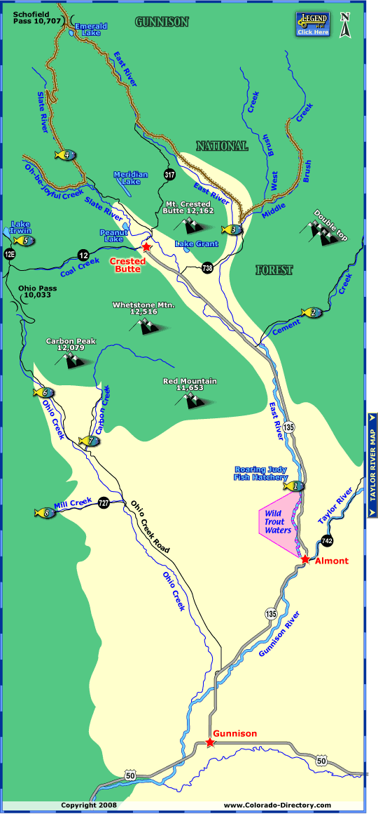
The East River begins north of Crested Butte with Emerald Lake in the central mountains of Colorado. It flows 35 miles to Almont where it meets the Taylor River to form the mighty Gunnison River. Anglers will find open fishing among the many tributaries of the East River.
- Roaring Judy Fish Hatchery
The area below Roaring Judy is designated Wild Trout Water. Bag and possession limit for trout is 2 fish under 12 inches, keeping Kokanee Salmon is prohibited. Fishing is prohibited between August 1st and October 31st. - Cement Creek
Public fishing access begins two miles for Highway 135 extending ten miles on Cement Creek. The creek yields brown, brook and cutthroat trout for an exhilarating experience. Sections of private property also exist so use caution. - Upper Reaches - East River & Brush Creek
The upper reaches of the East River provide some rocky bars and open casting opportunities. River flows can vary greatly from year to year because there's no damn on the river. The East River, Middle & West Brush Creek offer great fishing opportunities for rainbow, brown and brook trout. Be aware of private property throughout the area. - Slate River & Oh-be-joyful Creek
North of Crested Butte is a 4-Wheel Drive road along Oh-be-joyful Creek. There's five miles of public fishing along the creek. There's also a stretch of public fishing along the Slate River. If you continue along Slate River road you will encounter Emerald Lake and back down along the East River to Crested Butte. A 4-Wheel Drive vehicle is recommended for this particular route. - Lake Irwin
North of County Road (CR) 12 on CR 12E, Lake Irwin is a great for a leisurely day of fishing. Expect rainbow and brook trout in your catch. - Ohio Creek
There's a one mile stretch of public fishing six miles north/northwest of Carbon Creek. Further up Ohio Pass watch for a sign on the left marked "Beaver Ponds." There's one large pond a short walk from Ohio Creek Road and four more a little further west. - Carbon Creek
The lower section between Ohio Creek Road and Gunnison National Forest Boundary are private property. For one mile after the boundary is an open section of stream and beaver ponds for fishing. - Mill Creek
A small creek with feeding Ohio Creek, Mill Creek offers a fair population of brook and rainbow trout.
More Activities & Information
Gunnison, Colorado includes: Almont, Blue Mesa Lake, Ohio City, Parlin, Pitkin, Sargents, Sapinero, Taylor Park, Waunita Hot Springs
Fishing in Colorado
Antonito Area Fishing Map • Arkansas River Headwaters Fishing Map - East • Arkansas River Headwaters Fishing Map - North • Big Thompson River Fishing Map • Blue Mesa Reservoir & Gunnison River Fishing Map • Creede Fishing Map • Eagle River & Vail Area Fishing Map • East River Fishing Map • Elevenmile & Tarryall Reservoirs Fishing Map • Four Corners Area Fishing Map • Granby Area Fishing Map • Grand Mesa Fishing Map • Kremmling Area Fishing Map
• Lake City Fishing Map • Lake Estes Fishing Map • Middle Colorado River Fishing Map • North Fork South Platte River Fishing Map • Pagosa Springs Area Fishing Map • Rampart Reservoir Fishing Map • Red Feather Lakes & Poudre River Fishing Map • Rio Grande Area Fishing Map • San Juan River - Navajo Lake Fishing Map • South Park Fishing Map • Taylor River Fishing Map • White River Valley Fishing Map


Follow Us


