Colorado Snowmobiling
Vail & Red Cliff Park Snowmobile Trails
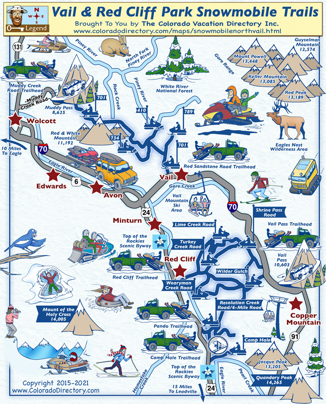
Snowmobiling Around Vail & Red Cliff Park
The White River National Forest and the Vail Pass Winter Recreation Area includes trails for all levels of riders from novices to pros. Some trails are more scenic than others, but each trail has plenty of scenic views as well as rugged terrain for those who desire more challenge in their snowmobiling experience. This area covers 55,000 acres and offers over 120 miles of motorized and non-motorized trails.
Taking a snowmobile into the pine forests is a unique way to experience the breathtaking beauty of the Rocky Mountains. This area has high elevation and great views, and offers some of the most spectacular snowmobiling in Colorado.
Please note: these trails are for multi-use so follow the designated trail signs and always watch for wildlife.
Snowmobile Trails South of Interstate-70
Red Cliff Trailhead/Parking Area - Trails accessed from this trailhead include Wearyman Creek Road, Turkey Creek Road, and Lime Creek Road. The trailhead is located just south of Red Cliff along Highway 24, parking will be on the east side and trails will run throughout the Vail Pass Winter Recreation Area connecting to the Vail Pass Trailhead.
Vail Pass Trailhead - Beginner riders will have a great time in this area. Shrine Pass Road, Shrine Pass Bowl, and Wilder Gulch Trail are made for the novice snowmobile riders. Access to the trailhead is along I-70, take exit 190 and follow signs for the rest area. You must check in at the visitors booth in the parking area, there may be a daily fee to use the trails.
Pando Trailhead & Camp Hale Trailhead - Both of these trailheads provide access to the same trails. The Resolution Creek Road/4-Mile Road ranges in difficulty from beginner to moderate. Camp Hale is a historic area of Colorado where the 10th Mountain Division trained for winter mountainous operations during WWII. Many ski resorts in Colorado were started by veterans that learned to ski in this area. The trailheads are located along Highway 24 south of Red Cliff.
Snowmobile Trails North of Interstate-70
Red Sandstone Road Trailhead & Muddy Creek Road Trailhead - Both of these trailhead connect to the same main trail, 701. There are a few trails that spur off of this main one but nothing that loops back around or connects to anything else. The Red Sandstone Road Trailhead is located along I-70 just outside of Vail. Access to the Muddy Creek Road Trailhead is north of Wolcott along Highway 131, turn east onto a dirt road, which will then turn into the snowmobiling trails.
Places to Stay & Fun Things to Do
Summer and winter fun 20 minutes west of Beaver Creek and Vail resort in Dotsero. Sage Outdoor Adventures: snowmobiling, ATVing, horseback rides, whitewater rafting, fishing, tubing, and kayaking.
More Local Information
Vail Area, Colorado includes: Avon, Beaver Creek, Dotsero, Eagle, Edwards, Minturn, Red Cliff, Wolcott
Snowmobiling in Colorado