
Local Area Map
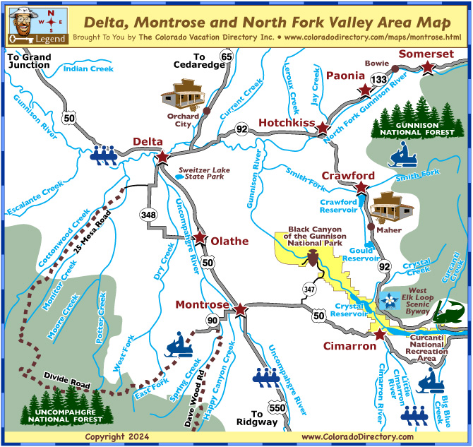
Delta, Montrose & North Fork Valley Area Map
Click on Map Icons below to Learn More About Activities in the Area
Not all towns appear on map. The publisher does not assume any responsibility for accuracy or completeness of maps. This information was compiled as accurately as possible.
Plan Your Colorado Vacation for the Montrose, Delta, Somerset and the Black Canyon of the Gunnison National Park Area in Southwest Colorado
This circle tour can be done over a weekend or a full week depending on how many stops your family wants to make and what adventures you are looking forward to on your Colorado Vacation. The circle tour is 178 miles and takes 4 hours to drive.
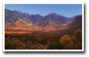
If you're looking for a unique experience, The Delta, Montrose and North Fork Valley Area might be the spot for you! Enjoy some of the best fishing and rafting in Colorado; the historic downtowns of each of these communities invites you to stroll, shop and dine; and feast on the worlds best fruits and vegetables. Plus, stunning mountain views that embrace you.
While you're out and about taking in all this part of Southwest, Colorado has to offer, be sure to keep an eye out for golden eagles, red-tailed hawks, prairie falcons and great horned owls that live in the Uncompahgre and Gunnison National Forests. Stop to photograph one of the three GHOST TOWNS: Orchard City, Bowie, and Mahar.
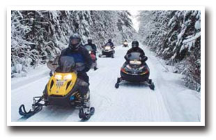
In the winter, SNOWMOBILING is the most popular outdoor activity with three groomed trail systems to choose from: Black Canyon Snowmobile Trails, Cimarron Snowmobile Trails and Montrose Snowmobile Trails. Tours and rentals are available, be sure to ask your lodging host for guidance.
Featuring these Colorado Towns: Cimarron, Crawford, Delta, Hotchkiss, Montrose, North Fork Valley, Olathe, Paonia, and Somerset
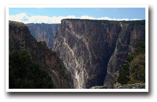
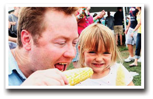
THE MONTROSE AREA offers amazing fishing opportunities along the Gold Medal Waters of the Gunnison and Uncompahgre Rivers. If you are feeling up to a morning drive head 20-miles east of Montrose and spend an afternoon in historic Cimarron with fishing, rafting and hiking along the Cimarron River, and boating on Crystal Reservoir, these great family opportunities could be right up your alley. Further southeast is Black Canyon of the Gunnison National Park, and Curecanti National Recreation Area with whitewater rafting and scenic picnic areas. Olathe is on Highway 50, between Delta and Montrose; the town-folks honor their amazing sweet corn the first Saturday in August at the Olathe Sweet Corn Festival. Stop in and enjoy the best sweet corn Colorado has to offer! Hop in a raft for a GUIDED SUMMER RAFTING TRIP on either the Gunnison River or the Uncompahgre River. You won't regret it.
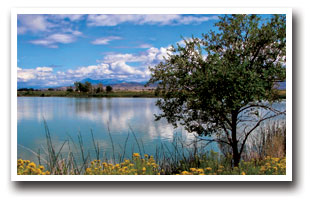
DELTA is in the states' "Banana Belt" its mild weather offers plenty of year-round recreational and cultural experiences for vacationers of all ages. After being greeted by The Ute Council Tree, an 85-foot Cottonwood used as a gathering location for tribal meetings, at the town's entrance, stroll Delta's downtown in search of the murals painted by local artists that adorn the downtown buildings. Every September Delta host the Council Tree Pow Wow American Indian Cultural Festival, this day long event features Native American dancers, singers, and workshops. You could also spend the day at nearby SWEITZER LAKE STATE PARK, which offers a wide variety of fun activities for the entire family, from action-packed boating, swimming and jet skiing, to the quiet of waterfowl watching.
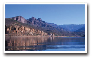
CRAWFORD is an adventurer's paradise offering outstanding big game hunting, excellent fishing, and spectacular hiking in Gunnison National Forest. Wake-up early for a day of fishing at Blue Mesa Reservoir or Crawford Reservoir, both feature boating, swimming, and picnicking. West Elk Loop Scenic Byway connects Crawford to both the North Fork Valley and Black Canyon of the Gunnison National Park. 4-1/2 miles east of Crawford is Needle Rock, the unofficial symbol of Crawford Country. Needle Rock is the remnant of an extinct volcanic plug rising 700 feet above Missouri Flats. The view is fantastic from the vistas of Needle Rock. From Crawford take Dogwood Avenue east out of town that turns into Needle Rock Road. Head east towards the Needle to the parking area. The out and back trail is a 0.8 mile and gains 541 feet in elevation. Keep an eye out for mountain goats up on the rock. Crawford has long been known for its cattle drive down its main street (Highway 92) each spring and fall. So grab your Stetson and strap on your spurs and join the locals in a cattle drive!
THE NORTH FORK VALLEY is a region on the Western Slope of Colorado that includes Somerset, Hotchkiss and Paonia. This is a land rich in history: coal, cattle and fruit are what drove the first settlers to the North Fork Valley from Lake City in 1880. In 1902 the railroad made its impact on the area, vastly changing the commercial scale of the fruit industry. Today, it's known for the world's best apples, peaches, cherries, apricots, and pears, along with wine grapes. Grab yourself some fresh fruit from one of the many local orchards and head into the Gunnison National Forest for a picnic.
DRIVING DIRECTIONS: To get to this part of Southwest Colorado you'll drive in on Highway 50 from north (I-70) and the east (Gunnison); from the south on Highway 550 from Ridgway. The Circle tour we suggest can start in Delta or Montrose along Highway 50 into the North Fork Valley along Highway 92 and 133; then head to the Black Canyon of the Gunnison and Cimarron along Highways 92 and 50, and then back to your starting point. This circle is 178 miles and takes 4 hours to drive.
Montrose Area Activities & Maps
National Parks and Monuments:
Black Canyon of the Gunnison National Park
Blue Mesa Reservoir/Curecanti National Recreation Area
Scenic Byways:
West Elk Loop Scenic Byway
Fishing:
Blue Mesa Reservoir & Gunnison River Fishing Map
Rafting & Kayaking:
Gunnison River Rafting & Kayaking
Little Cimarron River Rafting & Kayaking
Uncompahgre River Rafting & Kayaking
Snowmobiling:
Black Canyon Snowmobile Trails
Cimarron Snowmobile Trails
Montrose Snowmobile Trails
Local Area Maps:
Delta, Montrose & North Fork Valley Area Map
More Local Information
Montrose Area, Colorado includes: Cimarron, Olathe
North Fork Valley, Colorado includes: Hotchkiss, Paonia, Somerset

