
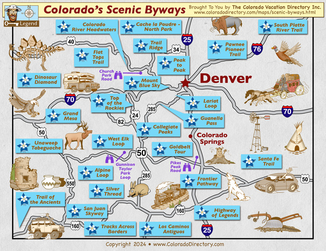
Colorado Scenic Byways Map
Click on the Columbines below to view Colorado Scenic Byway Maps
|
Alpine Loop Backcountry Byway This 65-mile route circles through the historic mining towns of Lake City, Silverton and Ouray in southwestern Colorado's backcountry. Travel up Cinnamon Pass and Engineer Pass for breathtaking views or sample the area's many hiking and biking trails. Cache la Poudre - North Park Scenic Byway Starting in Fort Collins, this 101-mile north-central Colorado trip winds through Roosevelt National Forest, Poudre Canyon and scenic North Park before dropping into the quiet town of Walden. Enjoy plenty of opportunities for hiking, wildlife viewing and fishing along the way. Church Park Road Scenic Drive Church Park Road connects travelers between Hot Sulphur Springs and Fraser, Colorado. Notable attractions include Blue Ridge and Byers Peak (12,804 ft.) in Arapaho National Forest. The tour spans approximately 24 miles and takes around two hours. Collegiate Peaks Scenic Byway Starting in Twin Lakes near the Continental Divide, this 58-mile north-central Colorado trip follows the Arkansas River to the east and the Sawatch Mountain Range to the west and continues north to Salida and Poncha Springs. It's a 90 minute drive or a full week of adventure, whitewater rafting, hiking, ATVing, ghost towns, hot springs, snowmobiling and skiing. Colorado River Headwaters Scenic Byway Travel alongside the roaring Colorado River on this 80-mile, north-central Colorado byway from Grand Lake to State Bridge. Don't miss Three Lakes Reservoir, fishing on the river's Gold Medal Waters near Kremmling and soaking in the therapeutic Hot Sulphur Springs. Dinosaur Diamond Scenic Byway Step back into prehistoric times on this 512-mile byway. Winding south from Grand Junction, drivers can explore excavation sites at Dinosaur National Monument, learn about the region's first people at Colorado National Monument and much more. Enchanted Circle Scenic Byway New Mexico Starting and ending in Taos, the 84-mile route takes drivers through scenic ski areas, past a Vietnam memorial and over winding roads seen in movies such as "Butch Cassidy and the Sundance Kid" and "Easy Rider." Flat Tops Trail Scenic Byway Pristine landscapes and an abundance of wildlife await drivers on this 82-mile north-eastern Colorado byway. Running from Yampa to Meeker, the route passes through White River National Forest and the Flat Tops Wilderness Area, vast swaths of beautifully preserved mountain land. Frontier Pathways Scenic Byway For a taste of variety, try this 103-mile byway, which passes landscapes from desert to mountain on its way from Pueblo to Colorado City along Highways 96 and 165. This south-central Colorado route passes the San Isabel National Forest, the ghost town Rosita and Bishop Castle. Gold Belt Tour Scenic Byway Composed of three roads (High Park Road, Shelf Road and Phantom Canyon Road), the 135-mile Gold Belt Tour takes drivers through many of south-central Colorado's former mining towns. Gamble in Cripple Creek, check out Florissant Fossil Beds' dinosaur bones and walk the suspension bridge at the Royal Gorge. Grand Mesa Scenic Byway For centuries, Native Americans, early settlers and - now - drivers have flocked to see the 11,000-foot Grand Mesa. This byway, running 63 miles from Cedaredge to Mesa, climbs to the top of the mesa and through the national forest that surrounds it. Guanella Pass Scenic Byway Just a few miles southwest of Denver, this 22-mile route takes drivers from Georgetown to Grant along County Road 381 & SH 62. Sites along the way include the historic Georgetown Loop Railroad, the former Silverdale mining camp and plenty of hiking and biking trails. Gunnison Taylor Park Loop Scenic Drive The loop passes through Parlin and Ohio City on County Road 76, east of Gunnison. There are several sites between Parlin and Taylor Park Reservoir. Ghosttowns include Quartz, Woodstock, Tincup, Abbeyville and Hillerton. High Road to Taos Scenic Byway New Mexico This 67-mile scenic byway takes drivers through several small Spanish-influenced towns that are home to historic buildings, beautiful artwork and astounding natural sites. Heading north from Santa Fe on US 285, drivers can access the beginning of the route by turning east on NM 503 and following it to NM 520. Highway of Legends Scenic Byway This 82-mile route allows drivers to discover some of southern Colorado's finest treasures. Running from Trinidad to Walsenburg, the route offers dazzling views of the Spanish Peaks, passes through San Isabel National Forest and summits Cucharas Pass. Jemez Mountain Trail Scenic Byway New Mexico This 163-mile scenic byway takes you from from Albuquerque to Santa Fe. Filled with tons of recreational opportunities, historic stops and chances to eat, relax and shop. Lariat Loop Scenic Byway Colorado's only urban byway, this 33-mile loop passes through the towns of Denver's Mountain Area, running from Golden and passing through Genesee, Evergreen and Morrison. Visit Buffalo Bill Cody's grave and Red Rocks Park, home to stunning rock formations and its famous natural amphitheater. Los Caminos Antiguos Scenic Byway This 129-mile route explores the towns of the San Luis Valley in southern Colorado before dropping into New Mexico. Sites along the way include Colorado's first church in Conejos and the home of boxing great Jack Dempsey in Manassa. Mount Blue Sky Scenic Byway Climbing 7,000 feet in 28 miles, Mount Blue Sky Scenic Byway is the highest paved highway in North America. The route starts in Idaho Springs and climbs to Mount Blue Skys' (fka Mount Evans) summit at 14,266 feet, offering stunning views, wildlife watching and hiking trails along the way. Pawnee Pioneer Trails Scenic Byway Traveling the same paths as Colorado's early Native Americans and settlers, this 125-mile route runs through northeast Colorado's rolling prairies. The road offers stunning views of the 250-foot-tall sandstone Pawnee Buttes, the Pawnee National Grasslands and the area's abundant wildlife. Peak to Peak Scenic Byway This 55-mile route, which starts in Central City and runs north to Estes Park along Colorado Highways SH 72 & SH 7, passes through some of Colorado's most popular destinations. Drivers can visit Rocky Mountain National Park, Allenspark, ghost towns, gold mines and historic Black Hawk. Pikes Peak Highway Scenic Drive This 12-mile byway climbs to the top of the world's second most visited mountain summit. Take in the spectacular scenery as the road winds to the top, where the view inspired the song America the Beautiful. San Juan Skyway Scenic Byway Passing through some of southwest Colorado's most historic places, this 236-mile byway loops through Durango, Telluride, Ouray and Cortez. Popular sites include Mesa Verde National Park, the Durango-Silverton Narrow Gauge Railroad and Chimney Rock Archaeological Area. Santa Fe Trail Scenic Byway An important 19th century trade corridor linking Mexico and the United States, the Santa Fe Trail is now closely paralleled by this byway, which loops through Colorado for 188 miles into New Mexico. Look for wagon wheel ruts along the road and historic Bent's Fort. Silver Thread Scenic and Historic Byway Historic and scenic, this 75-mile byway links South Fork and Gunnison via Lake City and Creede in Colorado's southwest. Look out for the beautiful North Clear Creek waterfalls, Wagon Wheel Gap - the first stage stop between South Fork and Lake City - and the area's many elk. South Platte River Trail Scenic Byway The shortest byway in Colorado, this 19-mile northeast route loops through Julesburg and its surrounding area. Don't miss Fort Sedgwick, the only Pony Express stop in Colorado, and the Julesburg State Wildlife Area. Top of the Rockies Scenic Byway Rarely dipping below 9,000 feet, this 75-mile, high-altitude route travels from Twin Lakes to Leadville before branching off to either Minturn or Copper Mountain. Don't miss the Camp Hale Memorial or the historic Tabor Opera House. Tracks Across Borders Scenic Byway New Mexico This 125-mile of largely undeveloped byway parallels or overlays part of the Denver and Rio Grande Western railroad's old narrow gauge route. Built in 1881, the railroad connected Chama, New Mexico to Durango, Colorado and ran until 1968, when almost all the track was torn up. Trail of the Ancients Scenic Byway Starting and ending at the border of Colorado and Utah, this 116-mile byway is filled with geological structures and historic sights. Don't forget to visit the Four Corners Monument and the Galloping Goose Railcar & Museum. Trail Ridge Road Scenic Byway One of Colorado's most popular roads, in Rocky Mountain National Park, this 48-mile scenic byway in north-central Colorado is America's highest continuous highway. It connects Estes Park and Grand Lake. Watch the trees disappear once the road passes timberline and look for Milner Pass, where the road crosses the Continental Divide. You usually can find some snow even in July to have a snowball fight with the kids. Unaweep Tabeguache Scenic Byway This 130-mile southwest Colorado byway passes through the Unaweep Canyon while traveling from Whitewater to Placerville. Take advantage of the many scenic hiking and biking trails and keep an eye out for historic remnants of the area's mining past along the way. West Elk Loop Scenic Byway This 205-mile loop takes drivers through Carbondale, Paonia, Gunnison and Crested Butte. Natural beauty abounds, but make sure to stop at Black Canyon of the Gunnison National Park and Blue Mesa Lake. |

